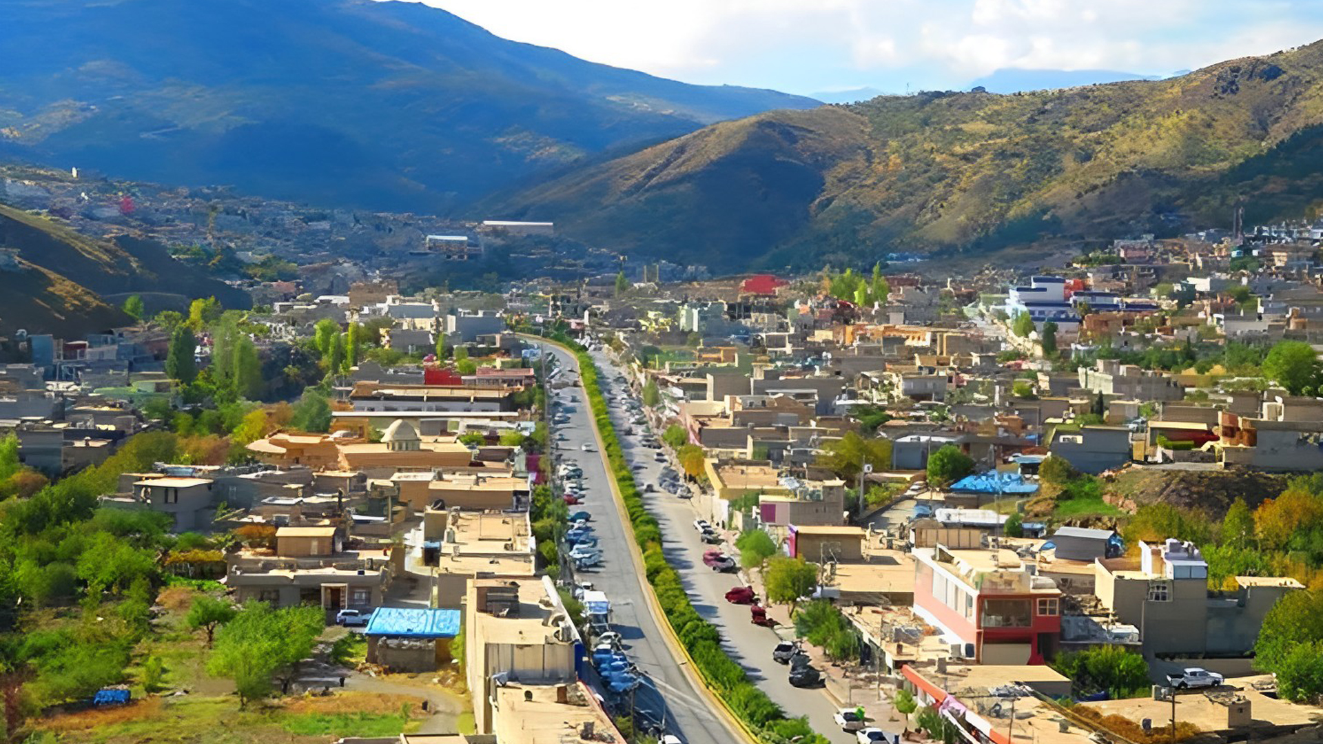
Diyana district is part of the Soran central district under the Soran autonomous administration. It comprises 22 villages with a population exceeding 70,000 as of the 2020 census. The district spans an area of 166 square kilometers and is strategically located with proximity to various other districts and the center of Erbil province. Established as a district in 1961 during Abdulkarim Qasim's rule, it was initially part of the Rwandz district. The district underwent administrative changes post the 1991 uprising and during the Ba'ath regime's rule in 1986-1987. The name "Diana" is believed to have originated from the word "Dian", highlighting the Christian community's significant contribution alongside Muslims.
Diyana is bordered by Syedkan to the north, Khalifan to the south, Smilan to the east, Mazne to the west, Soran to the south, and Rwandz to the southeast. Predominantly a plain area, it's apt for agriculture. However, recent developments have seen lands being used for community and government buildings, and some converted into factories. The district's climate, influenced by surrounding mountains, is conducive for diverse agricultural activities.
The district is home to both Muslims (98%) and Christians (2%), comprising men, women, and children.
Located within the Khalifan district of the Soran autonomous administration, Sareshma is renowned for its beauty. Elevated to district status in 2023, it was previously Khalifan's largest village. As of the 2020 census, it houses over 5,236 residents. The district's economy traditionally revolved around agriculture and livestock, but many now serve in the Peshmerga, are employed, or are involved in business. The name "Sareshma" is believed to have evolved from "three rashmals".
Geographical Location:
Sareshma is situated in the northwestern part of Khalifan district, a mere 5 km from Khalifan's center. It's in close proximity to Rwandz, Mazne, Harir, and the center of Khalifan district. The district enjoys a moderate climate, with cold winters attributed to heavy rainfall.
Social Status:
Regarding integration and social dynamics, the Sareshma community is cohesive and predominantly Muslim. The population comprises men, women, and children.
History of Warte District:
Warte district, situated within the Ruandz district of the Soran autonomous administration, had a population of approximately 6,341 people as of the 2020 census. Spanning an area of 22 km^2, Warte transitioned from a village to an official district in 2008 under the Kurdistan Council of Ministers' directive. Administratively, it falls under the Rwandz district and is predominantly inhabited by the Balak tribe, making it a significant part of the Balakayety region.
Geographical Location:
Warte is renowned for its picturesque landscapes, abundant vegetation, and water resources, making it a magnet for both local and international tourists. The district is nestled among several unique mountains, with some areas characterized by challenging terrains where the distance between mountains is as narrow as 50 meters. Notable mountains include the Karokh Mountain to the rear, known for its recreational and household significance, and the Drabi Mountain to the front, historically significant for the many political and civil wars fought there. The Jazila Mountain graces the district's right, while Zine Warte, with its seasonal beaches, lies to the left. The Khanaqa Valley, known for its distinct beaches, is also a part of this district. The climate is refreshing in the summer, thanks to the lush greenery and water sources, while winters are cold and rainy.
Warte district is home to 20 picturesque villages, including Rezanok, Banasartak, Dargala, Chomarkhin, Razhikarian, Sarnaws, Khanaqa, Chom Baroo, Barsul, Ziway Warte, Barozhi Warte, Sule Warte, Kelete, Cheneran, Gojar, Chom Raman, Bardgrka, Pardeshal, Zargali, and Bokriskan.
Social Status:
The district's inhabitants are predominantly Muslim, with a harmonious blend of men, women, and children. The community is known for its strong kinship ties and social cohesion.
History of Barmiza District:
Barmiza district, situated within the Syedkan district of the Soran autonomous administration, was elevated from a village to a district status in 2023 by the Council of Ministers of the Kurdistan Regional Government.
Dashti Barazgar, a prominent area within the district, is one of the most expansive plains situated on the Turkey-Iraq border, bridging the northern and southern parts of Kurdistan. This fertile plain, primarily inhabited by the Bradost tribe, plays a significant role in the Syedkan region.
The district is dotted with structures known as "castles," an Ottoman Turkish term denoting shelters for soldiers, particularly during winter. These castles, named after villages in the Bradost region, have an uncertain origin due to the absence of definitive documentation. However, certain Ottoman-era documents reference a castle named Kani Rash.
Historically, Barmiza has been a hotspot for political conflicts, given its strategic location between Turkey and Iraq. The district underwent reconstruction in 1993 within the Bradost plain near Kani Rash. However, between 1994-1997, the area faced evacuations and bombings by Turkish forces due to the PKK's presence. In 1997, the locals appealed to President Barzani for arms, showcasing their resilience and sacrifices for their homeland.
Geographical Location:
Barmiza boasts a captivating landscape, enriched with lush greenery, trees, and shrubs, especially in its urban areas. The district's location between the north and south is accentuated by the surrounding mountains, offering a cooler climate in summers compared to other regions. The district experiences humid summers and cold, snowy winters.
The district encompasses several villages on the Barazgar plain, including Kani Rash, Are, Aubra, Enemsid, Banawanok, Bandar, Chenare, Chamalwa, Khumari, Zarwa, Siro, Kharwana, Kewana Gund, Harone, and Hayat.
Social Status:
Predominantly Islamic, the community in Barmiza is known for its unity, kinship, and brotherhood, comprising men, women, and children.
History of Haji Omeran District:
Located within the Syedkan district of the Soran autonomous administration, Haji Omeran district was formerly the village of Barmiza. Elevated to district status in 2023 by the Kurdistan Regional Government, it comprises 19 villages with a population of approximately 5,508 as of 2020. The district's name, according to some sources, is derived from two pioneers named Omar and Omar from the early 19th century.
Geographical Location:
Situated in the northeast of Erbil, Haji Omeran borders Syedkan district to the north, Choman district to the west, Sulaimani province to the south, and Iran to the east. The district spans an area of 68,000 dunams, with the combined area of its villages totaling 51,169 dunams. Known for its lush landscapes, the district experiences cold winters with temperatures often dropping below zero and pleasant springs and summers, attracting numerous tourists.
Social Status:
The district's population is entirely Muslim, comprising an equal distribution of men, women, and children.
History of Smilan District:
Smilan district, under the jurisdiction of the Choman district in the Soran autonomous administration, has a population of approximately 4,697 as of 2020. It was officially designated as a district in 2000, named after its center, Smilan. Characterized by its mountainous terrain, the district is surrounded by peaks and valleys.
Geographical Location:
Located to the east of Choman district, Smilan neighbors Syedkan to the north, Warte to the south, and Soran to the west. The district, with its mountainous climate, receives significant annual rainfall.
Social Status:
The district's inhabitants are predominantly Muslim, with an even gender distribution.
History of Qasre District:
Qasre district, part of the Choman district in the Soran autonomous administration, encompasses 25 villages with a population of around 8,913. Spanning an area of 177 km^2, the district's name, "Qasre," has two interpretations. One suggests it means a very cold place. The district, which saw significant destruction during past regimes, was rebuilt post the 1991 uprising.
Geographical Location:
Situated 18 km from Choman district, Qasre is primarily an agricultural and tourist hub. The majority of its residents are engaged in farming, animal husbandry, and beekeeping. The district is known for producing nuts, cabbage, and apples, among other crops. Additionally, it boasts several tourist attractions frequented during the summer.
Social Status:
The district's population practices Islam, and the community is evenly split between males and females.